Project Highlight: Landform Reshaping and Erosion Modelling for Mine Rehabilitation and Closure Planning
The Sunshine Coast office assisted a client in transitioning their mining operations to the progressive rehabilitation and closure plan (PRC plan) framework.
Project Overview
The client operates a copper and gold mining operation in North West Queensland, with 32 granted mining leases covering an area of approximately 10,900 hectares (ha) that extends almost 70 kilometres (km) from north to south. The site has been subject to exploration and mining activities by several companies over the last 100 years, resulting in numerous legacy mining landforms. In 2013, the client recommenced mining operations following its acquisition.
Queensland Government’s Mined Land Rehabilitation Policy
A progressive rehabilitation and closure plan (PRC plan) is a critical element of the Queensland Government’s Mined Land Rehabilitation Policy. The Policy stipulates that all land disturbed by mining activities be rehabilitated to a safe and stable landform that does not cause environmental harm and can sustain an approved post-mining land use.
A final landform design is a key component of successful rehabilitation and closure planning. The final landform must be based on the proposed post-mining land use, and the ability to achieve a stable condition must be demonstrated.
Project Focus
ATC Williams was engaged to support the client’s transition to the PRC plan framework.
The scope of work included:
- Digital reshaping of existing landforms to produce conceptual final landforms.
- Erosion modelling of the typical sections to represent the conceptual final landforms and predict average annual erosion rates, ensuring they are the same or less than the erosion rates of the surrounding land. Additionally, this modelling was used to ensure the formation of concentrated flow paths was controlled through landform design to minimise the loss of capping materials and exposure of the underlying waste material.
Landform Reshaping and Erosion Modelling
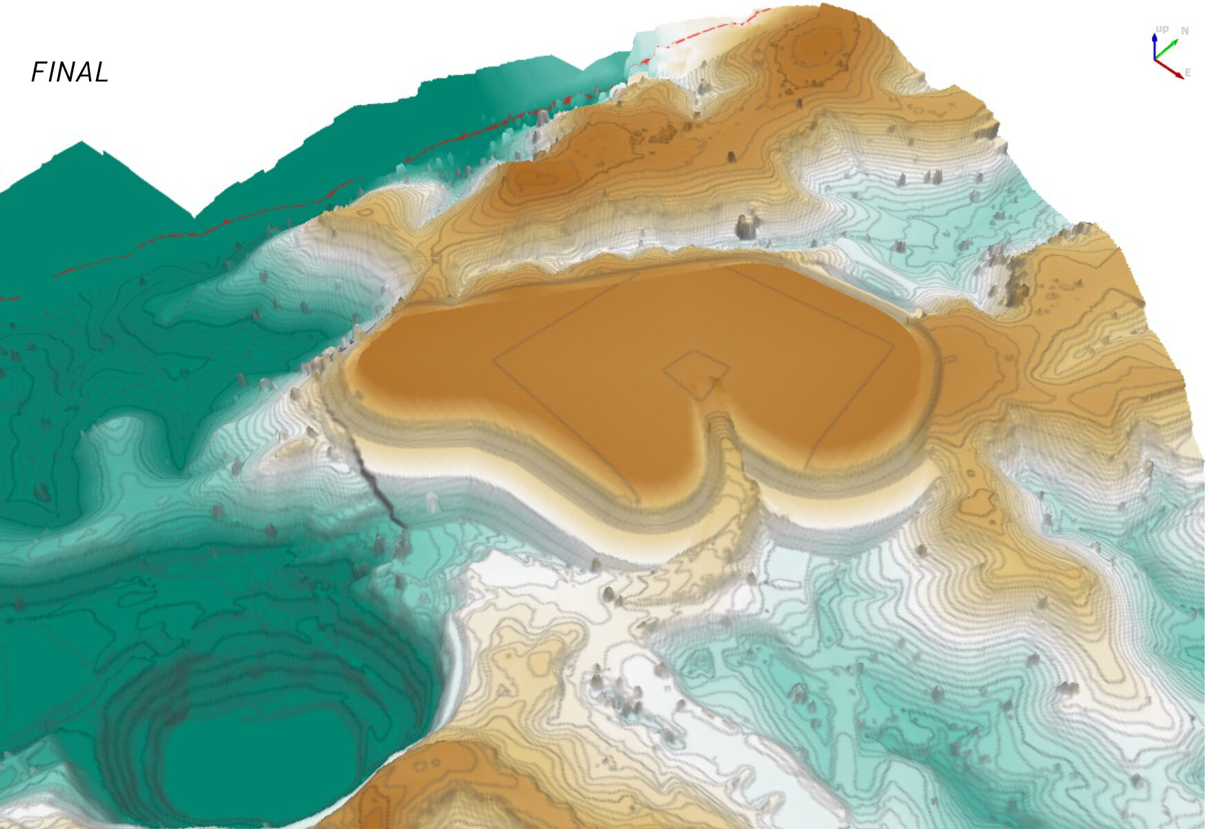
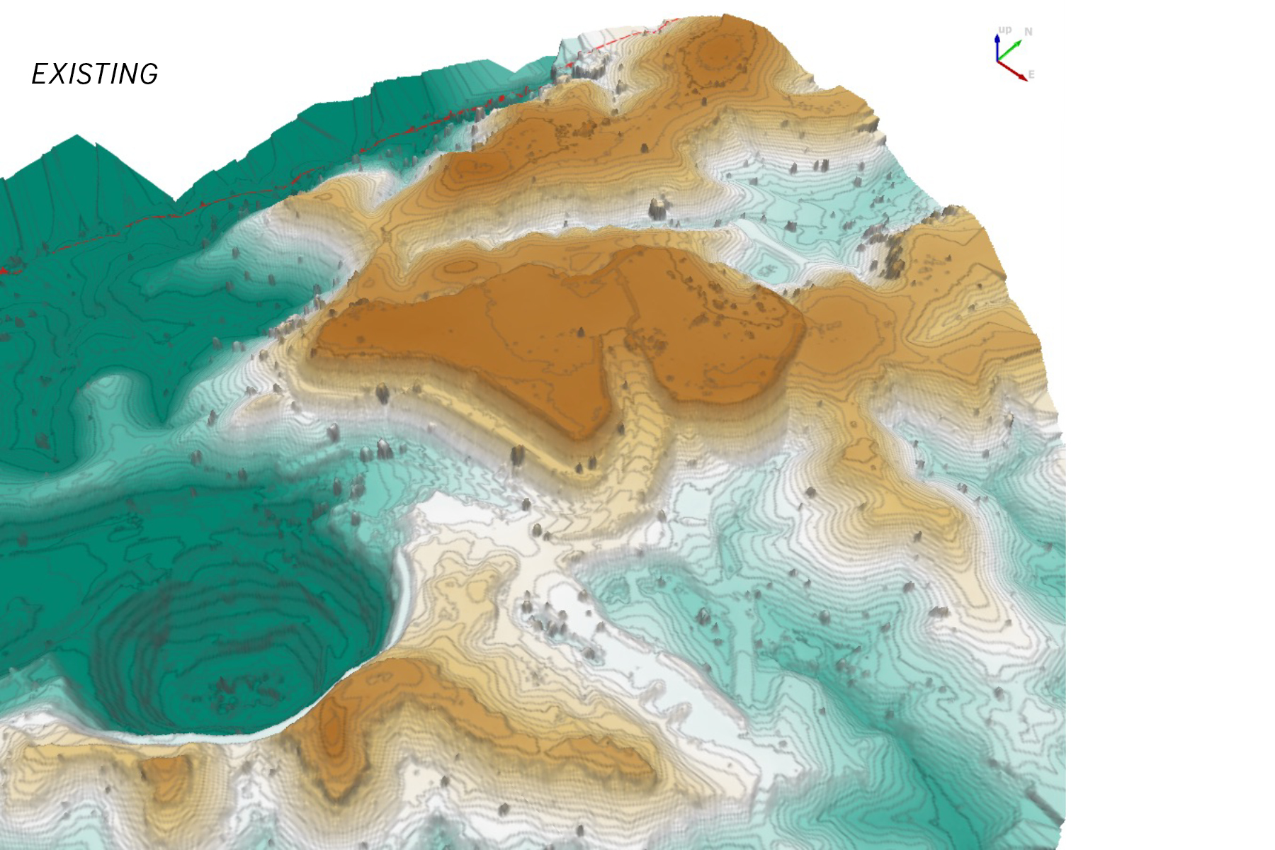
ATC Williams used LiDAR survey of the existing landforms to digitally reshape the existing landforms and create final landforms for closure within MUK 3D. MUK 3D is an advanced earthworks and tailings modelling software used to create, analyse, and visualise landforms quickly. Conceptual cover systems were incorporated into the final landform, where necessary.
Once each landform was reshaped, figures were produced to show the current, transition and final (closed) landform for inclusion into the PRC plan.
The reshaping process considered the following factors:
- Structure location, footprint, and height: These factors may be influenced by the location of environmental values, local topography, the location of sensitive receptors, or visual impact. Additionally, it is important to consider whether the water will be retained or shed.
- Identification of material available for landform rehabilitation: This included assessing the quantities available and required to achieve the landform design outcomes.
- Erosion assessments: These assessments are used to determine slope profile design and other factors that will affect the stability of the final landform, including vegetation, sheet flow path length and material characteristics of the available capping soils.
Erosion modelling of the typical sections of the conceptual final landforms was undertaken using the Water Erosion Prediction Project (WEPP). WEPP is a computer model developed by the United States Department of Agriculture (USDA) to predict average annual soil loss. The purpose of the erosion modelling was to demonstrate the ability of the conceptual final landforms to achieve stable conditions.
Client Benefit
This project demonstrates how ATC Williams can use its mine rehabilitation and closure expertise to help clients meet their regulatory obligations and achieve post-mining land use objectives.
Utilising digital reshaping and erosion modelling tools is a valuable way to assess the feasibility and stability of conceptual final landform designs. These tools can communicate the proposed final landform to stakeholders and support the application for a PRC plan. It was also valuable to identify potential earthworks quantities and rehabilitation timeframes and ensure appropriate water management controls are planned to benefit operations and closure.
The ATCW approach adopted for this project streamlined the complexity of closure for three mine sites, which saved the client significant consultancy costs and project management time across all aspects of the PRC plan requirements. The scope included Waste Rock Characterisation, Water Management, Landform Development, Materials Balance and Landform Evaluation Modelling. In total, ATCW reviewed and compiled PRC plan documentation suitable for submission to DES for 57 closure landforms and surfaces.
Mine Closure Capabilities
ATC Williams has diverse mine rehabilitation and closure capabilities that assist clients in developing and transitioning to the PRC plan framework.
These capabilities include:
- Landform Design
- Erosion Modelling
- Landform Evolution Modelling
- Cover System Design
To discuss your project, please contact the Sunshine Coast office on +61 7 5406 7000
We acknowledge the following staff involved in the project:
Nick Brown – Sunshine Coast Office Manager / Principal Engineer
John Milsom – Singleton Office Manager / Principal Engineer
Joel Eadie – Senior Engineer
Natascha Kotze – Engineer
Georgia Greening – Experienced Engineer